For Entertainment Purposes Only–Part II
There are times when general weather trends can be predicted with a relatively high degree of confidence a number of days into the future. But by and large, extended-range forecasting is fraught with peril.
Below is part two of my series on longer range weather prediction. Part I appeared on January 11. The material is drawn from my unpublished book, INSIDE THE WEATHER CHANNEL. Look for part three in the next week or two.
FOR ENTERTAINMENT PURPOSES ONLY–Part II
Extended-range Forecasts
EXPLODING SPAGHETTI FACTORIES
Meteorologists have a way of dealing with this uncertainty. It’s called ensemble forecasting. By repeatedly tweaking the initial conditions of a forecast–that is, the data that go into a model–allowances can be made for the various possibilities triggered by “flapping butterfly wings.” The result is an array, or ensemble, of predictions.
Forecasters aren’t really worried about butterflies, of course, they’re concerned about what’s going on in the atmosphere that they may not be aware of. The U.S. has the densest observational network in the world, but to our west, over the vast reaches of the Pacific Ocean and Asia, observations are sparse and a lot of detail is lacking. Satellite data help tremendously, but the atmosphere may still be pulling some undetected shenanigans. Ensemble forecasting attempts to guess at what those might be.
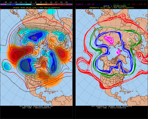
The forecast outputs for each individual ensemble member can be overlain on one another. This results, at least for upper-level wind patterns, which are important in determining surface weather, in something that looks like strands of spaghetti plopped down on a map. Figure 1b is the “spaghetti diagram” for a 72-hour forecast. It shows four selected contours (in purple, blue, green and red) overlain with the results from individual ensemble predictions.

Figure 1a. A 72-hour ensemble mean. Figure 1b. The corresponding “spaghetti diagram.”
The white contour is the operational, or primary, run of the model. The important thing to note is that the ensemble members in Figure 1b are actually pretty close together, that is, there isn’t much difference among the various model runs. This indicates there’s not a lot of forecast uncertainty, at least in the upper-air pattern, three days into the future. Figure 1a is the ensemble mean, or smoothed average, of all the predictions. It’s very close to the operational run of the model, a good indication that all is well in the forecast world.

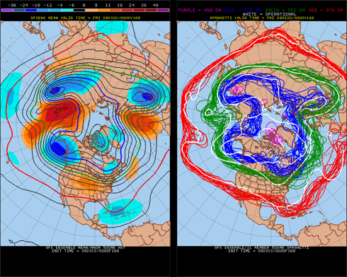
Figure 2a. A 168-hour ensemble mean. Figure 2b. The corresponding “spaghetti diagram.”
Seven days down the road (Figure 2b), however, things start to unravel, especially over the north Atlantic where the green contours are all over the place suggesting, at least in that area, a great deal of forecast ambiguity.
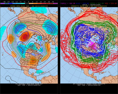
Ten days into the future (Figure 3b), the ensemble members certainly aren’t singing “Kumbaya.” In fact, it looks as if a spaghetti factory has exploded. This suggests that using the operational model run (white contours) to make a prediction would be futile. Might as well trust your fate to economists.

Figure 3a. A 240-hour ensemble mean. Figure 3b. The corresponding “spaghetti diagram.”
The examples shown in Figures 1 through 3 (courtesy of Pennsylvania State University) are for just one model, a U.S. model called the Global Forecast System (GFS). It’s run routinely 16 days into the future four times a day and is the only operational model that peers that far ahead. But I suspect it can’t see very well much of the time, given the spaghetti typically splattered all over its crystal ball.
There are several other global models that forecasters regularly consult. One of the best is from the European Centre for Medium-Range Weather Forecasts (ECMWF), a consortium headquartered near London. Forecasters refer to this model as the “Euro.” It’s run twice a day and cranks out predictions ten days in advance.
Other models include the “U.K. Met” from the United Kingdom’s meteorological service; the NOGAPS, a U.S. Navy model; and the Canadian, run by our neighbors to the north.
Exploding spaghetti factories are bad enough when a forecaster is trying to divine what the weather will be a week in the future, but it’s even worse when two different, usually reliable, models don’t even seem to be on the same planet. There was one case several years ago when the GFS showed a generally benign west-to-east upper-air flow across the country. The Euro, on the other hand, suggested a humdinger of a storm somewhere over the northeastern quarter of the nation. It was enough to make a weatherman’s head explode, much less the old spaghetti shop. A Global Forecast Center meteorologist once described such model differences as being “comically massive.” A great characterization.
Given the tremendous amount of ambiguity sometimes facing forecasters, it’s no surprise that Weather Channel meteorologists have developed their own jaundiced jargon for certain extended-range efforts. One of the best terms: fantasycast. They never just make stuff up, of course; they attempt to maintain continuity from day to day and not make any massive changes based on a single model run. But at times they know they’re merely extrapolating a low-probability outlook into an even lower probability future.
Photo: NWS Preliminary Hazards Assessment (issued February 4, 2010).
A return to much colder weather is in the cards for much of the country next week following this weekend’s Mid-Atlantic snowstorm/blizzard.